Be prepared to be impressed.
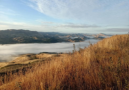
Starting at a privately owned common (we will disclose this location nearer to the start date). Traversing Mt Erin and the iconic Te Mata Peak, the course will cross private land, and take in some incredible breathtakingly Hawke's Bay scenery. The course is rugged, testing and very rewarding. Enjoy beautiful ancient woodland, craggy ridge top views, scenic farmland, fun single track and gravel/lime stone roads.
Solo Two Peaks - 35 kms approx.
Solo Two Peaks competitors will complete the entire course. Please see below for details of the course. You can run/walk, MTB or E-MTB.
It is a considerable distance to cover two peaks (35 kms) in one day and you MUST move swiftly in order to complete the full course, before the cut-off time. If you are uncertain you can complete 35 kms in less than 10 hours, we highly recommend you try the One Peak Explorer option.
One Peak Explorer - 20 kms approx.
Each year competitors have the option to complete one of the three peaks. The course rotates across the three peaks each year, and this year’s peak is Mt Erin. So if going solo for 35 kms doesn't spin your wheels, or you can't find a partner to do a relay team with you, this is a great solution! Low-key and non-competitive. You can still explore private land, and be part of the buzz of the event! You can choose to run/walk, MTB or E-MTB.
See the below description for Leg 1 for details of your course.
You must organise your own transport to the start and from your finish (Matangi Road transition area) to the Finish Line/event village at the Black Barn Olive Shed, Havelock North.
Limited free van transport will be provided for those unable to get to the start.
You will also need to collect your timing transponder from registration on Friday night.
Relay Teams
Choose from run, walk, MTB, E-MTB. Open category, including schools.
The Course Legs and Maps
LEG 1 - MT ERIN (distance 20 kms approx. - total elevation gain 597m approx.)
Participants on Leg 1 will start race proper from a privately owned common (location will be revealed closer to the date) straight up a steep incline onto private farmland. After negotiating various valleys and ridges, you will have a steady climb to the top of Mt Erin (489 m) (steep pinch near the top!). Followed by a fast and fun descent down along the Tukituki River to the Transition at Matangi Road.
LEG 2 - TE MATA PEAK (distance 15 kms approx. - total elevation gain 847m approx.)
Participants on Leg 2 pass through the cattle yards at Matangi Road, and then traverse beautiful farmland on the western side of the Tukituki. Upon reaching the base of Te Mata Peak, competitors will ascend to the Saddle Car Park along beautiful single track, past the Giant Redwoods and Karaka Grove. Crossing Te Mata Peak Road the course will follow the ridge line north through rolling farm land to reach the technical single track descending towards Waimarama rd. From here it’s just less than 2km along the recently restored lime stone track to the finish line at the Black Barn Olive Shed.
Cut-off Time
There will be one cut-off time. This will be at Matangi Road Transition (before the start of Leg 2) Leg 1 cut-off will be 4.5 hours (12:00pm). If a competitor does not reach the transition by this time, they will be transported to the finish line (if you are a solo competitor who has entered 2 peaks, your time will be moved in to the 1 peak categories accordingly).
Transition Points
Competitors in a relay team who are doing Leg 2 must make their own way to the Transition at Matangi Road, off Waimarama Road. This will be easily accessible by car, and plenty of parking will be available. No buses will be provided. The distance from Black Barn Olive Shed is 9 km and takes 15 minutes to drive.
Bag Drop
For Two Peaks competitors, we will have a bag drop area at the start line for you to put aside bags of gear that you wish to be taken to finish line at Black Barn Olive Shed. Supporters are allowed at the Matangi Road Transition station.
Directional Signage
Large red arrows will be strategically placed around the course to ensure you do not get lost. The directional signage will be clear and easy to navigate.
Additional Timing Checks
There will be additional timing checks at the top of Mt. Erin and at the Tauroa Road Car Park to keep track of all the competitors’ progress. You will have to make sure you pass through these Timing Gates at these points. They will be clearly marked at their location.
Event Preparation
TWO PEAKS is a challenging event that should not be underestimated. The hills are steep and some of the terrain is technical. You WILL be challenged!
For those mountain biking, please be prepared to carry your bike on a few short sections. There may be gates and fences to climb over.
Whilst the terrain is picturesque, it is also exposed in places. You could experience strong winds, rain or blistering sunshine. We encourage competitors to be well prepared with suitable clothing, food and water. You may consider taking a hat, sunblock, electrolytes and your mobile phone (in a sealed bag).
For more details on TRAINING for both the solo and team categories, please CLICK HERE
Training and Land Access
Whilst it is essential to undertake plenty of training prior to the event, it is very important that you do NOT attempt to access the private land that will be used for much of the course. This is very important. If competitors are found to be accessing private land in advance of the event, the individual involved (and their team) will be disqualified.
We are very grateful to the landowners for entrusting us with accessing their land. Please treat it with respect.
Aid Stations
Whilst we do encourage you to bring your own water and food, Aid Stations will be provided in strategic locations. There will be an Aid Station at Matangi Road Transition. It will be well stocked with water and bananas/lollies. At the top of the 2 summits, you will also find water and bananas. Please bring sufficient water for yourself and treat our supplies as backup. No cups provided – better for the environment!
Medical Attention
If you require medical attention, please talk to the nearest marshal, who will refer to you the event director and medic. All medical situations should be channelled through the Event Director only. A medic will be available on each of the 3 peaks, as well as a medic team at the Finish Line and Transition. If you are competing and see someone who is injured, please be considerate, and stop to assist. As the course is not always easily accessible, part of the safety plan is that we look after each other.
Roads are Open
Please note that, whilst you will spend a very short time on public roads, the roads will still be open to traffic (apart from the top of Te Mata Peak). You MUST obey the road rules and you MUST obey directions given to you by marshals. Any issues will result in disqualification.
Race Regulations
Please READ the Race Regulations.
It contains vital advice and information that is relevant to ALL competitors.
Extreme Weather
In the unlikely event of Force Majeure or extreme weather conditions, the event may be cancelled at any time. We will communicate this to all participants via email, the website and Facebook. In this situation entry fees are non-refundable. Best endeavours will be made to re-schedule the event. If the event is re-scheduled and you are unable to attend on the new date, your entry fee will not be reimbursed.
ENTER NOW
Note One
The course description is subject to change and should be referred to as a guide only.
Note Two
Competitors must remain on the course at all times, and must not deviate from the marked tracks. Gates/fences and other items on the land must not be tampered with, and all rubbish must be removed.